
We’ve posted thousands of nature photos over the past five years. These 20 made people lose their minds
We manage social media account with almost two million followers and post travel photography daily. After five years and thousands of images, we wondered: which natural locations generate the most engagement?
The answer required serious number-crunching. We analyzed every nature post from the past five years, excluding anything man-made – cities, monuments, structures. Pure landscapes only. Then we tracked three metrics: likes, comments, and shares. The data revealed clear winners.
These 20 locations didn’t just perform well. They dominated every metric, generating engagement rates that dwarfed our average posts. Some doubled our typical likes. Others triggered comment threads hundreds deep. The patterns were undeniable.
This isn’t editorial opinion or travel writer hyperbole. It’s hard data from millions of real interactions, revealing which natural wonders genuinely captivate people in 2025.
1. Banff National Park, Canada – Turquoise Lakes and Majestic Peaks
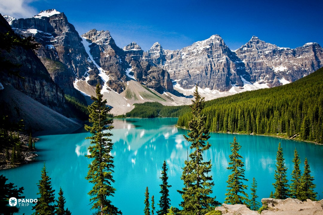
Canada’s first national park encompasses Rocky Mountain terrain in Alberta, containing peaks over 3,000 meters, dense conifer forests, and turquoise glacial lakes. Lake Louise and Moraine Lake rank among the most famous lakes in Canada, their vivid blue-green color created by rock flour – fine glacial sediment that reflects light. The park supports grizzly bears, elk, and mountain goats, while the town of Banff and the historic Fairmont Chateau Lake Louise provide accessible bases for exploring this vast wilderness.
Why It Breaks the Internet?
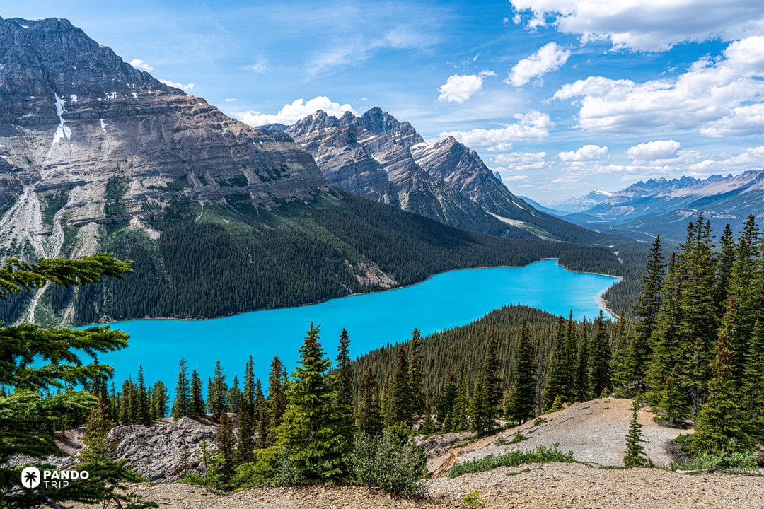
Moraine Lake in the Valley of the Ten Peaks might be Banff’s most photographed site and one of Canada’s most famous landmarks (it appeared on the $20 bill). From the Rockpile viewpoint, the scene is perfect: turquoise lake below, ten rugged peaks often topped with snow, sometimes a red canoe paddling the mirror surface. The symmetry and color contrast – orange sunrise on gray peaks reflecting in blue water – create extraordinary images. Lake Louise offers similar appeal with Victoria Glacier at the far end and the grand hotel opposite. Peyto Lake, viewed from Bow Summit, appears almost neon-teal and wolf-head shaped from above.
The color palette drives the viral appeal. That unnatural turquoise against dark forests and gray-white peaks, often under bright blue skies or dramatic clouds. September adds golden larch trees for extra contrast. Winter transforms the lakes into milky blue ice with snow-covered peaks – equally photogenic but completely different. Every angle in Banff resembles a postcard, which explains why photos consistently dominate travel feeds and wish lists.

Travel Facts:
- Location: Alberta, Canada. Main access via Banff town (1.5-hour drive west of Calgary). Park includes Lake Louise area and stretches along Continental Divide
- Best time to visit: July-August for full lake color and hiking access (expect crowds). Late June or September offer good weather with fewer visitors. Late September brings golden larches. Winter (December-March) ideal for skiing and frozen landscapes
- Must-see highlights: Moraine Lake (sunrise recommended), Lake Louise (sunset for alpenglow on glacier), Peyto Lake (Bow Summit view), Johnston Canyon (turquoise creek and waterfalls – spectacular when frozen)
- Access note: Moraine Lake Road closed to personal vehicles year-round. Book Moraine Lake shuttle, bus, or guided tour
- Photography tips: Strong altitude sun requires polarizing filters for water colors. Morning offers calmest water for reflections before afternoon winds
- Wildlife: Best viewing early morning or dusk along Bow Valley Parkway. Maintain safe distances and never feed animals
2. Salar de Uyuni, Bolivia – The World’s Largest Salt Flat and Natural Mirror

Salar de Uyuni is the world’s largest salt flat, covering 10,582 square kilometers of Bolivia’s Altiplano at 3,650 meters elevation. This vast expanse of white salt, visible from space, formed when prehistoric lakes evaporated, leaving behind a salt crust ranging from two to ten meters thick. For most of the year, it presents as a cracked white desert of hexagonal salt patterns stretching endlessly to the horizon – one of South America’s most extraordinary natural wonders.

Why It Breaks the Internet?
Between November and March, rainwater transforms the salt flat into Earth’s largest natural mirror. A thin water layer creates perfect sky reflections across thousands of square kilometers, erasing the horizon line completely. This infinity mirror effect produces surreal photographs where people appear to walk on clouds or float in sky. The images look digitally manipulated but aren’t – just physics creating impossible scenes.
During dry season, the geometric salt polygons create equally compelling visuals. The pure white surface allows for perspective-trick photography that went viral years before social media existed. Add pink flamingos, giant cacti on rocky outcrops, and trains rusting in the desert, and every element seems designed for maximum visual impact. Star Wars filmmakers chose this location for exactly this reason – it already looked alien.

Travel Facts:
- Best time to visit: Late December–February for peak mirror effect during rainy season. May–November for geometric salt patterns. Late April can offer both conditions
- Dimensions: World’s largest salt flat at 10,582 km², altitude 3,650m. Salt crust depth 2–10m
- Temperature: Nights cold year-round due to altitude
- Unique accommodation: Palacio de Sal – world’s first salt hotel, built entirely from salt blocks including walls, furniture, and décor
3. The Dolomites, Italy – Jagged “Pale Mountains” That Glow at Sunset
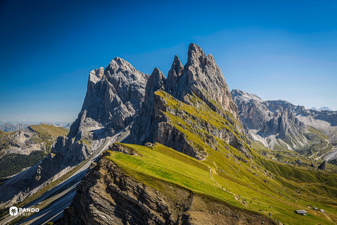
The Dolomites rise across northern Italy’s Trentino-Alto Adige and Veneto regions, featuring 18 peaks above 3,000 meters with distinctive sawtooth profiles of pale limestone and dolomite rock. These mountains appear light gray by day but transform at dawn and dusk through enrosadira – when the pale rock glows pink and orange. The range combines dramatic vertical walls with gentle alpine meadows, creating scenes from Tre Cime di Lavaredo’s three towers to Alpe di Siusi’s rolling pastures beneath the Sassolungo group.

Why It Breaks the Internet?
Tre Cime di Lavaredo generates massive engagement with its three fortress-like peaks arranged in perfect compositional balance. Sunset shots showing pink alpenglow on the towers, or night images with the Milky Way above, consistently go viral. Seceda Ridge in Val Gardena rivals it – the steep grassy slope suddenly dropping into jagged spires, with a fence line leading the eye upward, creates an irresistible foreground-background contrast.
The Dolomites excel at visual juxtaposition. One frame captures delicate wildflowers and wooden mountain huts against vertical cliffs looming overhead. The mountains’ distinct shapes – razor-edged Cinque Torri, the fortress-like Sella Group – provide instant recognition. Every element seems designed for maximum drama: emerald lakes like Carezza reflecting pale peaks, morning mist filling valleys below sharp ridges, or snow dusting the towers while meadows stay green.

Travel Facts:
- Region: Northern Italy (South Tyrol/Alto Adige, Trentino, Belluno provinces). Gateway cities: Bolzano, Cortina d’Ampezzo, Trento
- Cortina d’Ampezzo: Called “Queen of the Dolomites,” recognized as one of the world’s premier winter villages with Olympic heritage and legendary ski slopes
- Best time to visit: Late June-September for hiking and wildflowers (July-August busiest). Late September-October for autumn colors and valley mist with fewer crowds. December–March for winter scenes and skiing (high roads may close)
- Key locations: Tre Cime di Lavaredo (loop hike), Seceda (lift from Ortisei), Alpe di Siusi (Europe’s largest alpine meadow), Sella Pass and Gardena Pass (scenic drives), Marmolada (highest peak with glacier)
- Cultural note: Mix of Italian and Austrian influences – German and Ladin languages common. Dual place names normal (e.g., Brixen/Bressanone)
4. Northern Lights in Arctic Scandinavia (and Iceland) – Dancing Auroras in the Polar Sky

The Aurora Borealis occurs when charged solar particles collide with Earth’s atmosphere, creating visible light displays in high-latitude regions. Arctic Scandinavia (northern Norway, Sweden, and Finnish Lapland above the Arctic Circle) provides optimal viewing conditions with extended winter darkness, frequent clear skies, and minimal light pollution. Key viewing bases include Tromsø in Norway, Abisko in Sweden, and Iceland’s remote areas.

Why It Breaks the Internet?
Aurora photography dominates social feeds because the phenomenon looks impossible – ribbons of green light rippling across stars in patterns that change by the second. Long exposures reveal colors invisible to the naked eye: electric greens mixed with purple edges, pink bursts, and rare yellow streaks. The most viral shots layer these elements: aurora reflected in fjord water, silhouetted pine forests creating leading lines, or a lit cabin providing scale against the cosmic display.
Every aurora event is unique, which drives constant sharing. A mild display might show subtle green bands, while major storms produce full-sky explosions of color. Time-lapse videos showing the lights’ fluid motion consistently outperform static images. The contrast works perfectly for social media – bright neon colors against black sky, often with snow-covered foregrounds adding another luminous element.

Travel Facts:
- Region: Northern Scandinavia (Northern Norway, Swedish Lapland, Finnish Lapland), plus Iceland
- Season: Late September through late March for polar night darkness
- Peak activity: Around equinoxes (September and March), typically 11pm–2am. Solar activity follows 11-year cycles
- Viewing conditions: Clear, cold nights essential. Tours offer “aurora chases” to find breaks in cloud cover
- Reality check: Natural phenomenon requiring patience and solar wind activity – no guarantees despite operator claims
5. Lavender Fields of Provence, France – Endless Purple Rows under the Summer Sun

Provence’s lavender fields bloom each summer across southern France, with the Plateau de Valensole hosting the most extensive cultivation. These agricultural landscapes feature parallel rows of lavender extending to the horizon, often punctuated by stone farmhouses or solitary trees. The fields produce lavender oil commercially, but their visual impact during peak bloom has made them one of Europe’s most photographed seasonal phenomena.

Why It Breaks the Internet?
Valensole Plateau dominates lavender-related social content for one reason: perfect natural geometry. Rows create leading lines that photographers cannot resist – they converge at vanishing points that make even amateur shots look professional. The color combination drives engagement: deep purple against Mediterranean blue sky, with adjacent golden wheat fields adding a third primary color. The famous lone tree near Valensole appears in thousands of posts annually, its isolation emphasizing the purple expanse.
Sunrise and sunset transform these fields into glowing landscapes. Golden hour light makes purple appear luminous, while dawn mist between rows adds atmospheric depth. Close-up shots work equally well – lavender spikes frame portraits, creating natural bokeh. Drone footage reveals the fields’ true scale, showing purple rectangles carved into the countryside like agricultural art. The repetitive pattern satisfies something fundamental about visual perception, making viewers pause and save.

Travel Facts:
- Location: Provence, France (Valensole plateau in Alpes-de-Haute-Provence, plus areas near Sault and the Luberon)
- Peak bloom: Late June to mid-July for Valensole. Higher elevation fields near Sault peak mid to late July. Early August brings harvesting
- Access: Fields are working farms – free to view but respect private property signs
- Best light: Sunrise or sunset for rich colors and fewer tourists. Midday sun can wash out purple tones
- Etiquette: Don’t pick lavender – farmers harvest for oil production
- Nearby attractions: Golden sunflower fields often bloom simultaneously. Hilltop villages like Gordes and Roussillon provide elevated views of purple valleys
6. Lago di Braies, Italy – Emerald Alpine Lake Framed by the Dolomites

Lago di Braies (Pragser Wildsee in German) sits at 1,496 meters in South Tyrol, northern Italy, surrounded by Dolomite peaks including the Croda del Becco that rises directly above the water. This small alpine lake displays turquoise-green water in summer, its color created by limestone particles suspended in glacial melt. Dense forests line the shores, and the lake’s clarity allows mountain reflections on calm days – making it one of Italy’s most photographed natural wonders.

Why It Breaks the Internet?
The wooden boat dock on the north shore creates the perfect compositional anchor. From this point, rowboats in the foreground lead to mirror-like water reflecting jagged peaks – a layered image that performs exceptionally on social platforms. The water color drives engagement: bright teal in direct sun shifting to deep emerald in shadow, contrasting against pale gray cliffs and dark pines.
Seasonal variations multiply the lake’s appeal. Autumn brings golden larch reflections that double the color impact. Winter transforms the scene to monochrome, with partial ice creating geometric patterns. An Italian TV series featured the location, amplifying its popularity. The shoreline curve naturally guides viewers’ eyes toward the mountains, while wooden rowboats add human scale and nostalgic appeal. Every element aligns for maximum visual impact.

Travel Facts:
- Best time to visit: June–September for vibrant water and boat rentals. Very early morning essential to avoid crowds. October offers foliage reflections with fewer visitors. Winter brings ice patterns but no boat access
- Specifications: Altitude 1,496m, maximum depth 36m
- Boat rentals: Available summer months for recreating iconic shots
- Trail: 3.5km loop around lake provides multiple viewpoints
- Crowd warning: Peak season mid-day sees extreme tourist numbers – plan for dawn or late afternoon visits
7. Lofoten Islands, Norway – Dramatic Arctic Peaks Rising from the Sea

The Lofoten archipelago extends above the Arctic Circle in northern Norway, where granite peaks rise directly from the sea to heights exceeding 1,000 meters. Despite its latitude, the Gulf Stream moderates temperatures, allowing fishing villages to thrive year-round. Red wooden cabins (rorbuer) line sheltered bays beneath vertical mountain walls, creating the stark contrasts that define Lofoten’s landscape.
Why It Breaks the Internet?
Reine and Hamnøy generate the highest engagement rates among Arctic destinations. The formula works every time: red fishermen’s cabins on stilts reflected in still water, backed by peaks like Olstind that appear impossibly steep. The color palette – bright red against deep blue sea and gray-green mountains – creates instant visual impact. Wide-angle lenses exaggerate Lofoten’s already extreme topography, making mountains appear to lean over villages.
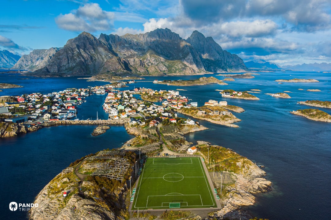
The Henningsvær football field exemplifies why Lofoten content spreads: a regulation pitch on a rocky islet surrounded by ocean, mountains forming the backdrop. It’s surreal yet functional. Arctic light adds another dimension – summer’s midnight sun bathes scenes in golden light for hours, while winter darkness brings aurora displays over snow-covered peaks. Even basic compositions succeed here because the natural geometry is so extreme. Vertical mountains meeting horizontal sea create drama in every frame.

Travel Facts:
- Season timing: June–August for midnight sun (no sunset late May to mid-July), green landscapes, hiking access. December–March for northern lights, snow scenery, orca sightings (limited daylight)
- Geography: Main islands (Austvågøya, Vestvågøya, Moskenesøya) connected by bridges and tunnels. Peaks reach 1,100m (Higravstinden: 1,161m)
- Population: 24,000 spread across the archipelago
- Weather: Changes rapidly – rain gear essential year-round
- Light conditions: Sun doesn’t set for six weeks in summer, doesn’t rise during polar night in winter – unique lighting defines the photographic appeal
8. Palawan, Philippines – Tropical Paradise with Limestone Cliffs and Turquoise Lagoons

Palawan stretches across the western Philippines, featuring limestone karst formations, lagoons, and coral reefs along its 1,780-kilometer coastline. El Nido at the northern tip serves as gateway to the Bacuit Archipelago, where dozens of limestone islands rise vertically from the water. These karst formations, similar to those in Vietnam’s Ha Long Bay, create enclosed lagoons with water clarity exceeding 30 meters visibility. Coron to the north adds freshwater lakes and World War II wreck diving to the geological variety.

Why It Breaks the Internet?
Big Lagoon in El Nido generates exceptional engagement through its enclosed geometry – turquoise shallows surrounded by 100-meter limestone walls create a natural amphitheater effect. Drone footage reveals the full contrast: aqua water against gray cliffs topped with jungle vegetation. The water color gradients from pale turquoise in shallows to deep blue at cliff bases provide the layered depth that makes images compelling.
Traditional outrigger boats (bancas) add perfect scale references against the massive karsts. Sunrise and sunset multiply the visual impact – golden light on gray limestone while water retains its blue tone. The formations create maze-like channels that reveal new compositions at every turn. Water clarity allows visibility of coral formations and fish from above, adding another dimension to aerial shots. Every element combines for maximum “tropical paradise” impact without appearing artificial.

Travel Facts:
- Best timing: November to May for dry conditions. March–May sunniest but hottest. December–February offer cooler temperatures with calm seas. June–October brings rain and typhoon risk
- Key bases: El Nido for Bacuit Archipelago tours. Coron (Busuanga Island) for wreck diving and Kayangan Lake
- Natural highlight: Puerto Princesa Subterranean River National Park on western Palawan – 8.2km underground river flowing to sea, one of Asia’s premier natural wonders
- Access: Flights to El Nido or Puerto Princesa from Manila. Island-hopping tours essential for reaching lagoons and beaches
9. Lauterbrunnen Valley, Switzerland – A Storybook Alpine Valley of 72 Waterfalls

Lauterbrunnen Valley cuts through the Bernese Oberland as a glacial U-shaped valley bordered by 300-meter vertical cliffs hosting 72 waterfalls. Staubbach Falls, the most prominent, drops 297 meters (approximately the height of the Eiffel Tower) creating a fine mist that gives it its name (“dust stream” in German). The valley floor sits at 800 meters elevation, overlooked by the Jungfrau massif including peaks exceeding 4,000 meters. J.R.R. Tolkien used Lauterbrunnen as inspiration for Rivendell, cementing its place as one of the most famous places to visit in Switzerland.

Why It Breaks the Internet?
Staubbach Falls behind grazing cows in alpine meadows creates the composition that dominates Switzerland tourism content. The scale contrast drives engagement – tiny wooden chalets against massive cliff walls, with a ribbon waterfall connecting sky to valley. Late afternoon sun illuminates the mist, creating golden translucence and occasional rainbows that photograph exceptionally well.
The valley excels at layered compositions: wildflower foregrounds, middle-ground villages, background waterfalls, and snow-capped peaks above. This vertical stacking of elements gives every image depth. Morning mist adds atmosphere, while the sound of cowbells in videos triggers sensory memories. Wengen village, accessible only by cogwheel train, appears suspended on the cliff face in wide shots. The combination of dramatic verticals (waterfalls, cliffs) with peaceful horizontals (meadows, villages) creates visual tension that stops scrolling.

Travel Facts:
- Location: Bernese Oberland, Switzerland. Nearest city Interlaken. Valley connects to car-free villages Mürren and Wengen via cable cars and trains
- Best time to visit: May-September for peak waterfall flow from snowmelt and green meadows. June-July brings wildflowers and maximum water volume. Early autumn offers foliage with good flow. Winter reduces some falls to trickles
- Key measurements: Staubbach Falls: 297m drop. Valley floor: 800m elevation. Surrounding peaks: Jungfrau (4,158m), Eiger, Mönch
- Access: Walk between Staubbach Falls and Trümmelbach Falls (inside mountain) or take local bus
- Unique fact: Lauterbrunnen remains one of few global destinations where BASE jumping has never been banned, attracting extreme sports enthusiasts year-round
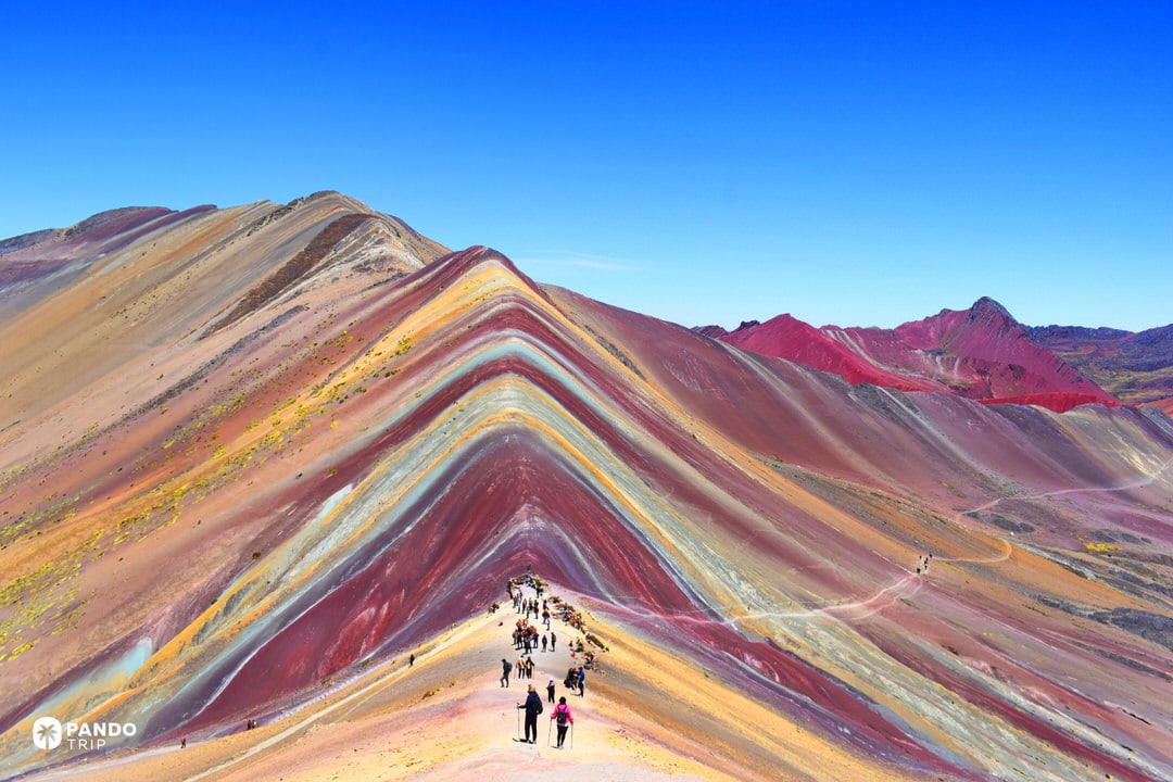
10. Rainbow Mountain (Vinicunca), Peru – The Striped Mountain of Seven Colors

Vinicunca sits at 5,036 meters in the Peruvian Andes near Cusco, displaying mineral stripes across its slopes in reds, ochres, yellows, greens, and purples. These bands formed from sedimentary layers containing different minerals – iron oxide creates reds, chlorite produces greens, sulfur yields yellows. Snow covered these colors until glacial retreat revealed them around 2015, quickly transforming an unknown peak into Peru’s second-most visited attraction after Machu Picchu.

Why It Breaks the Internet?
The view from the main lookout shows Vinicunca’s striped face in full display – horizontal bands of contrasting colors that appear painted rather than natural. Maroon red adjacent to mustard yellow creates stark visual patterns rarely seen in nature. The surrounding landscape of brown peaks makes the rainbow stripes more dramatic, while deep blue Andean sky intensifies the color saturation.
Scale references like hikers or alpacas emphasize the mountain’s size while proving the colors are real, not digital manipulation. Morning light hitting the angled slopes makes colors appear to glow. The geometric precision of the stripes – perfectly parallel bands following the mountain’s contours – creates patterns that trigger immediate double-takes. Social platforms flooded with Vinicunca images because viewers assume they’re seeing digital art until multiple sources confirm reality.
Travel Facts:
- Best time to visit: June-August for dry conditions and clear views (peak crowds). May and September offer good weather with fewer visitors
- Access: 3-hour drive from Cusco plus 2-3 hour hike (or horseback ride) to viewpoint. Start early to beat day-trip crowds
- Altitude warning: 5,000+ meters requires acclimatization in Cusco. Altitude sickness common without preparation
- Conditions: Below freezing at dawn even in dry season. Snow can temporarily obscure colors. Layer clothing essential
- Alternative: Palcoyo offers similar colored mountains with easier access and fewer crowds
11. Sardinia, Italy – Caribbean-Blue Seas and Pristine Beaches in the Mediterranean

Sardinia spans 24,000 square kilometers as Italy’s second-largest island, with 2,000 kilometers of coastline ranging from white-sand bays to limestone cliffs. The Costa Smeralda in the northeast gained fame in the 1960s when developed as a luxury destination, but the island’s appeal extends far beyond this enclave. Water clarity around Sardinia reaches 30 meters visibility due to minimal river runoff and protected marine areas. Ancient nuraghe stone towers dot the mountainous interior, while the coast delivers consistent azure waters that rival any tropical destination.

Why It Breaks the Internet?
La Pelosa beach near Stintino dominates Sardinia content with its shallow sandbar creating gradient turquoise bands extending 200 meters from shore. A 16th-century watchtower on Isola Piana provides the compositional anchor that makes every shot instantly recognizable. Cala Goloritzé, accessible only by boat or steep trail, offers different appeal: a 143-meter limestone pinnacle rises beside a tiny cove where water appears electric blue against white pebbles.
The Mediterranean’s clarity creates the “floating boat” effect that generates massive engagement – vessels appear suspended above their shadows on sandy bottoms. Granite formations at beaches like Capriccioli add sculptural elements, while the bear-shaped rock at Capo d’Orso provides scale and whimsy. Golden hour transforms these scenes, warming the pale rocks while water retains its cyan tone. The simplicity works perfectly for social media: clear water, color gradients, natural geometry, minimal crowds in shoulder seasons.

Travel Facts:
- Best time to visit: June-September for beach conditions. July-August hottest and busiest. June and September ideal with warm seas and fewer crowds. May and October pleasant but some facilities closed
- Key areas: Costa Smeralda (northeast) for luxury and emerald waters. La Pelosa (northwest) for shallow lagoons. Gulf of Orosei (east) for cliff-backed coves like Cala Luna. Chia and Villasimius (south) for long beaches with dunes
- Access: Car rental essential for exploring multiple beaches. Many premium coves require boats or hiking (Gulf of Orosei beaches mostly boat-access only)
- Water activities: Visibility averaging 20-30 meters makes snorkeling and diving exceptional
- Culinary note: Coastal restaurants serve fregola pasta with seafood and local mirto liqueur – integral to the Sardinian beach experience
12. Mount Fuji, Japan – An Iconic Volcano Reflected in Tranquil Lakes

Mount Fuji rises 3,776 meters as Japan’s tallest peak, visible from Tokyo 100 kilometers away on clear days. This nearly symmetrical volcano, dormant since 1707, sits between Yamanashi and Shizuoka prefectures, with five lakes on its northern flanks providing reflection opportunities. The Fuji Five Lakes (Kawaguchiko, Yamanakako, Saiko, Shojiko, and Motosuko) formed from lava flows damming rivers, creating the viewing platforms that make this natural wonder in Japan one of the most photographed landmarks in the world. UNESCO recognized Mount Fuji as a World Cultural Heritage site for its artistic and spiritual significance.

Why It Breaks the Internet?
Lake Kawaguchi generates the highest engagement, particularly from its northern shore where seasonal elements frame perfect reflections. Summer lavender fields, spring moss phlox, and autumn maple tunnels provide foreground color against Fuji’s white cone. Chureito Pagoda in Arakurayama Sengen Park creates Japan’s most viral composition: five-tiered red pagoda, cherry blossoms, and snow-capped Fuji aligned vertically. This single viewpoint appears in millions of posts annually, especially during the two-week sakura window.
The mountain’s geometric perfection drives its shareability. That triangular profile reflected in still water creates symmetry that cameras love. Lake Motosu offers the exact view featured on Japan’s ¥1,000 note – proof of its compositional power. Telephoto lenses compress distance, making Fuji loom dramatically behind cultural elements like torii gates or fishing boats. Color combinations work perfectly: white snow against blue sky, vermillion structures, pink sakura, or red maples. Even Fuji-Q Highland’s roller coasters with the mountain backdrop generate viral videos. Every element combines to create images that epitomize Japan.

Travel Facts:
- Location: Straddles Yamanashi and Shizuoka prefectures, 100km west of Tokyo. Fuji Five Lakes accessible by bus/train to Kawaguchiko
- Best visibility: December-February offers clearest air and full snow cap (cold, bare trees). Cherry blossoms early-mid April at Kawaguchiko. Autumn late October–early November for fall colors. Summer hazy with reduced snow
- Top viewpoints: Chureito Pagoda (10-minute stair climb), Lake Kawaguchi north shore, Lake Yamanaka Panorama Dai (sunrise), Lake Motosu “¥1,000 view” (requires hike), Hakone’s Lake Ashinoko
- Photography timing: Dawn and dusk for calmest water and best light. Midday often backlit or hazy. Telephoto compression makes Fuji appear larger behind foreground elements
- Climbing season: July-August only for summit attempts. Sunrise from top (goraiko) draws thousands daily
13. Plitvice Lakes National Park, Croatia – A Cascading Wonderland of Turquoise Lakes and Waterfalls

Plitvice Lakes National Park contains 16 terraced lakes connected by waterfalls across 295 square kilometers of Croatian highlands. The lakes formed through travertine deposition – dissolved limestone creating natural dams that separate water bodies at different elevations. This geological process continues today, with minerals determining lake colors from azure to emerald based on depth and algae content. Wooden boardwalks traverse the system, allowing visitors to walk directly over some of the famous waterfalls in the world while maintaining one of the most beautiful places in Europe.

Why It Breaks the Internet?
Veliki Slap, the park’s 78-meter waterfall, anchors many viral images, particularly from overlooks showing boardwalks zigzagging below for scale. But the smaller cascades generate equal engagement – shots from the Lower Lakes section where walkways pass inches above turquoise water create immersive perspectives. Multiple waterfalls layered in single frames showcase the park’s vertical complexity.
Water color drives the visual impact. Direct sunlight produces near-neon turquoise, while shaded areas shift to deep emerald – both contrasting against brown travertine and green forest. Autumn multiplies the palette with red and orange reflections. Winter transforms everything to white and turquoise minimalism. Drone footage reveals the full pattern: interconnected lakes resembling natural terraces. Close-ups of boardwalks curving between cascades make viewers feel present in the scene. The water clarity allows fish to appear suspended in air, adding another surreal element that prompts shares and saves.

Travel Facts:
- Best time to visit: April-June for peak waterfall flow from snowmelt and wildflowers. September-October for autumn colors and smaller crowds. Summer beautiful but overcrowded (visit early morning or late afternoon). Winter offers frozen waterfalls though some trails close
- Park logistics: Open year-round. Full circuit takes 5-6 hours covering Upper and Lower Lakes via paths, boats, and shuttles
- Safety note: Wooden boardwalks become slippery from spray or ice – proper footwear essential
- Restrictions: Drones prohibited without special permission. Swimming banned to preserve water quality (nearby Korana River offers alternative)
- Photography tip: Overcast conditions enhance water colors by reducing contrast and eliminating harsh shadows
14. Torres del Paine, Chile – Towering Granite Spires in Windswept Patagonia

Torres del Paine National Park spans 1,810 square kilometers in Chilean Patagonia, centered on the Paine Massif that rises independently from the Andes. Three granite towers – Las Torres – reach 2,500 meters, while the Cuernos del Paine display distinctive black slate caps atop granite bases. Glacial lakes including Pehoé and Nordenskjöld show intense turquoise from suspended minerals, with Grey Glacier feeding into one of the world’s most stunning winter lakes. The park transitions from pampas grasslands supporting guanaco herds to southern beech forests and active glaciers.

Why It Breaks the Internet?
Las Torres at sunrise generates peak engagement – after a pre-dawn hike, first light hits the vertical spires, turning granite from gray to glowing red-orange. The composition works perfectly: three towers above milky glacial lake, creating vertical drama with horizontal reflection. This moment, lasting perhaps ten minutes, drives thousands to attempt the challenging night hike annually.
Cuernos viewpoints from Lake Pehoé offer different appeal – horn-shaped peaks reflected in vivid turquoise water with golden grass foreground. Patagonia’s volatile weather adds dynamic elements: lenticular clouds wrapping peaks, sudden rainbows, or light beams breaking through storm clouds. Time-lapse videos showing weather cycling through “four seasons in an hour” consistently go viral. Guanacos grazing with towers behind provide scale and life against geological grandeur. The visual formula combines extreme vertical elements, jewel-toned water, and rapid atmospheric changes that make every image feel alive.

Travel Facts:
- Location: Magallanes Region, Chilean Patagonia, 2.5 hours from Puerto Natales
- Best time to visit: December-February for warmest weather, long days, full trail access (peak crowds). November and March offer shoulder season benefits – spring flowers or autumn colors with more solitude. June-August brings snow, closed facilities, but dramatic winter landscapes with minimal visitors
- Trekking options: W-trek (4-5 days) or O-circuit (7-9 days) access all major viewpoints. Day hikes reach key vistas like Mirador Cuernos for non-trekkers
- Name origin: “Paine” means blue in Tehuelche language, reflecting the park’s dominant water color
- Weather warning: Conditions change hourly – carry full layers for sun, rain, wind, cold regardless of forecast
- Wildlife: Guanacos common near park entrance, foxes occasional, pumas increasingly visible near boundary estancias
15. Vermont (USA) in Autumn – New England’s Fiery Fall Foliage Spectacle
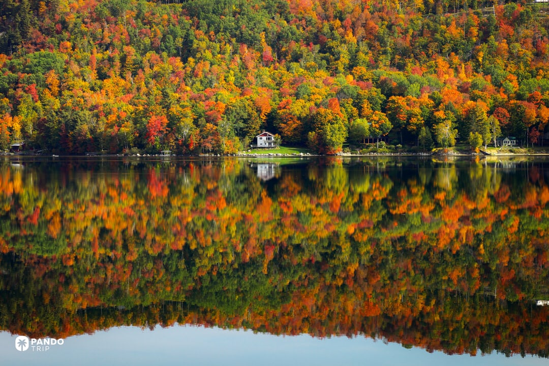
Vermont’s landscape comprises 70% hardwood forests dominated by sugar maples, birches, and oaks across the Green Mountains. These deciduous trees produce New England’s most concentrated fall display when chlorophyll breaks down each autumn, revealing carotenoids (yellows/oranges) and anthocyanins (reds). Vermont contains the highest density of sugar maples in the United States, which generate particularly intense red pigmentation due to high sugar content in their sap.

Why It Breaks the Internet?
Stowe village with Mount Mansfield backdrop creates Vermont’s most shared composition – white church steeples and red barns punctuating hillsides ablaze with color. Sleepy Hollow Farm in Woodstock, with its winding road through maple canopy, appears in millions of autumn posts. Lake reflections double the visual impact, creating perfect symmetry of fiery trees above and below waterlines.
The color contrasts drive engagement: warm reds and oranges against dark evergreens and blue October skies. Morning valley mist adds atmospheric depth to already saturated hillsides. Drone footage reveals the full scope – entire mountainsides appearing to glow in golden hour light. Vermont’s maple concentration means roads become tunnels of red, while every curve reveals new color combinations. The density and variety create images that appear digitally enhanced but represent nature’s actual display.

Travel Facts:
- Peak timing: Late September to mid-October, varying by elevation and latitude. Early October typically optimal for most areas
- Chemistry note: Temperature swings between warm days and cool nights trigger anthocyanin production, creating signature reds
- Scenic routes: Route 100 and Green Mountain Byway offer prime viewing corridors through color concentrations
- Maple connection: Vermont produces 3+ million gallons of syrup annually – over half of U.S. output. March’s Maple Open House Weekend showcases traditional sugarhouses
16. Hạ Long Bay, Vietnam – Thousands of Karst Islands in an Emerald Sea

Hạ Long Bay spans 1,553 square kilometers in northern Vietnam’s Quảng Ninh Province, containing over 1,600 limestone karst islands formed through 20 million years of erosion. These pillars rise vertically from emerald waters, their green vegetation creating a seascape recognized by UNESCO as a World Heritage Site. The name translates to “Descending Dragon,” referencing local legend about dragons creating the islands. Traditional wooden junks with rust-red sails navigate between formations containing caves, arches, and hidden lagoons.

Why It Breaks the Internet?
Ti Top Island viewpoint delivers the overview that dominates Vietnam tourism content – hundreds of karst pillars scattered across green water like a geological archipelago. At water level, junk boats sailing between towers provide scale and movement, their red sails contrasting against limestone gray and jungle green. Dawn and dusk transform the bay: karsts become black silhouettes against colored skies, creating layered compositions resembling traditional ink paintings.
Atmospheric conditions multiply the visual appeal. Morning mist creates depth with near islands sharp and distant ones fading to gray layers. The water’s emerald color – from shallow depths and marine algae – harmonizes with vegetation-covered limestone. Even overcast weather enhances the mood, with formations appearing and vanishing in fog. This combination of vertical elements, color contrasts, and atmospheric variation generates images that appear painted rather than photographed.

Travel Facts:
- Location: Quảng Ninh Province, 170km east of Hanoi. Access via Halong City or tours from capital
- Best conditions: October-November and March-April offer warm, clear weather ideal for photography. May–September brings heat, humidity, storms. December-February cooler with atmospheric fog
- Cruise logistics: 1-2 night cruises recommended for sunrise/sunset views and reaching quieter areas. Seaplane flights available for aerial perspectives
- Alternative bays: Bái Tử Long Bay (northeast) and Lan Hạ Bay (south) offer similar scenery with fewer boats
- Photography notes: Sea spray requires lens cleaning cloth. Drones capture stunning overviews but check regulations
- Activities: Kayaking through caves and arches provides intimate perspectives impossible from larger vessels
17. Zhangjiajie National Forest Park, China – The Real-Life Avatar Mountains

Zhangjiajie National Forest Park in Hunan Province contains over 3,000 quartz-sandstone pillars rising up to 200 meters from subtropical forest floors. These formations developed through 380 million years of erosion, creating the dense cluster of vertical columns that inspired the floating mountains in James Cameron’s Avatar. Part of the larger Wulingyuan Scenic Area (UNESCO World Heritage Site), the park includes the 1,080-meter “Southern Sky Column” – officially renamed Avatar Hallelujah Mountain – and features the Bailong Elevator, which ascends 326 meters up a cliff face.

Why It Breaks the Internet?
Yuanjiajie viewpoint captures the quintessential Zhangjiajie shot – isolated pillars appearing to float when morning mist fills the valleys between them. The unique verticality creates compositions unlike typical mountain photography: freestanding columns rather than connected ridges, each topped with stunted pines that survived centuries on bare rock. Layered depth develops naturally as pillars recede into fog, creating separation between foreground and background elements.
Golden Whip Stream offers the inverse perspective – looking up at vine-covered walls with macaque monkeys providing scale against massive formations. Seasonal variations multiply visual interest: summer’s green vegetation clinging to brown sandstone, winter’s snow frosting highlighting pillar geometry. Dawn light hits pillar tips while valleys remain in shadow, creating glowing peaks against blue backgrounds. The modern Zhangjiajie Glass Bridge adds human scale when included in wide shots. Every composition works because the geology itself is so distinctive – even foggy silhouettes immediately prompt location questions.

Travel Facts:
- Location: Hunan Province, 30km from Zhangjiajie city/airport. Often combined with Fenghuang Ancient Town or Tianmen Mountain (featuring “Heaven’s Door” cliff opening)
- Best time to visit: September-November for comfortable weather and clear skies. April-May brings mist and greenery (with rain). Summer peak season means heat, humidity, crowds. December-February offers snow-dusted pillars with fewer visitors
- Park logistics: Multiple entrance gates (Zhangjiajie Forest Park, Wulingyuan) with internal bus system. Key sections: Yuanjiajie (Avatar views), Tianzi Mountain (panoramas), Golden Whip Stream (valley walks)
- Crowd management: Gates open 7-7:30am – arrive early to avoid waits. Cable cars and elevators bypass extensive stairs
- Glass bridge: Separate ticket required for Zhangjiajie Grand Canyon location
- Photography note: Tianzi Mountain sunrise spectacular with cooperative clouds. Protect gear from aggressive macaques on trails
18. Ice Caves, Iceland – Crystal-blue Glacial Wonderland

Iceland’s glacial ice caves form annually within Vatnajökull (Europe’s largest glacier) and other ice masses when meltwater carves temporary chambers through compressed ice. These caves exist only in winter when temperatures stabilize the structures – summer melt causes collapse, with new formations appearing each year in different configurations. The famous Crystal Ice Cave near Jökulsárlón showcases the phenomenon at its most dramatic, though Kötlujökull offers year-round caves featuring blue ice mixed with volcanic ash layers. Iceland is home to the most beautiful ice caves in the world due to the unique combination of glacial size and volcanic activity.

Why It Breaks the Internet?
The blue intensity stops viewers immediately – dense glacial compression filters all light wavelengths except blue, creating an almost electric color impossible to replicate artificially. Classic compositions place a bright-jacketed figure beneath rippled ice ceilings resembling frozen waves, with entrance light creating white contrast against deep blue interiors. Texture variations multiply visual interest: bubble inclusions form turquoise mosaics, while smooth sections appear like polished glass.
Long exposures capture water drops as silky streams, adding motion to static ice. Natural framing occurs constantly – tunnel perspectives looking toward daylight with ice arches creating perfect circles. The silence broken only by dripping water translates into images conveying otherworldly atmosphere. Questions about authenticity flood comments because the blue appears too saturated for nature, yet represents accurate color capture of this compressed ice phenomenon.

Travel Facts:
- Location: Primarily Vatnajökull National Park, southeast Iceland. Tours depart from Jökulsárlón or Skaftafell. Kötlujökull near Katla Volcano offers year-round access
- Season: November through March when ice remains stable. Tours typically mid-November to late March. Early morning departures mean fewer crowds
- Safety requirements: Certified guide mandatory – glacier terrain contains hidden crevasses. Tours include 4×4 transport and short ice hike with provided crampons
- Temperature: Hovers around 0°C/32°F inside caves. Waterproof gear essential due to dripping melt
- Photography guidelines: Tripod necessary for low-light conditions. Protect equipment from water drops. Natural light preserves blue tones – flash destroys color and atmosphere
19. Jiuzhaigou Valley, China – Multicolored Lakes and Waterfalls in a Fairyland Valley

Jiuzhaigou Valley spans elevations from 2,000 to 4,500 meters in northern Sichuan Province, containing over 100 lakes colored by calcium carbonate deposits and specific algae species. This UNESCO World Heritage site’s name translates to “Valley of Nine Villages,” referencing Tibetan settlements within the reserve. The lakes display distinct colors – sapphire, turquoise, emerald, and purple – often within single bodies of water due to varying depths and mineral concentrations. Water clarity allows visibility to 40 meters depth, revealing submerged logs preserved by the calcium-rich environment.

Why It Breaks the Internet?
Five Flower Lake (Wuhua Hai) generates maximum engagement with its peacock-feather color pattern – five distinct hues from amber-yellow through jade-green to deep sapphire in one shallow lake. Submerged logs crisscross the lakebed, visible through crystal-clear water, creating natural geometric patterns. Autumn multiplies the visual impact when surrounding forests turn red and gold, their reflections mixing with the lake’s inherent colors to create nature’s most vivid palette.
Nuorilang Falls provides different appeal – a 320-meter-wide curtain waterfall that freezes into blue ice walls in winter, creating rainbow mists in summer. Five Color Pond displays near-neon blue clarity in a compact pool. Long Lake offers classic mountain reflections on calm days. The visual formula combines vibrant water colors with pristine surroundings – teal against green forest and white peaks. Perfect clarity creates mirror effects so precise that flipped images appear identical. Every element aligns to create scenes that prompt immediate location questions.

Travel Facts:
- Location: Northern Sichuan Province. Access via 10-hour bus from Chengdu or flight to Jiuzhai-Huanglong Airport plus 1.5-hour drive
- Peak timing: Mid-October for spectacular foliage combined with lake colors (busiest period). May brings snowmelt-fed waterfalls and flowers. Winter offers serenity with frozen features. Summer provides lush greenery but occasional rain
- Park logistics: Y-shaped valley system served by eco-buses. Visitors typically ride up, walk down on boardwalks between scenic spots. Extensive walking required for comprehensive viewing
- Altitude considerations: Tourist areas at 2,000–3,000m elevation. Acclimatization recommended for low-elevation visitors
- Access restrictions: Daily visitor numbers capped. Advance booking essential, especially peak season
- Preservation rules: Swimming prohibited to maintain water quality. Water temperature remains cold year-round regardless
20. Waitomo Glowworm Caves, New Zealand

The Waitomo Glowworm Caves on New Zealand’s North Island contain colonies of Arachnocampa luminosa, a bioluminescent gnat larva endemic to New Zealand. These insects produce blue-green light through a chemical reaction, using the glow to attract prey to silk threads they suspend from cave ceilings. The limestone cave system formed over 30 million years, creating chambers including the Cathedral (noted for acoustics) and the underground river where boat tours navigate. The glowworm grotto represents one of New Zealand’s must-do natural attractions, where thousands of larvae create a living constellation on the cave ceiling.

Why It Breaks the Internet?
Long-exposure photography reveals the full impact – thousands of blue-green points against absolute darkness create images resembling deep space photography. The unique blue hue distinguishes Waitomo from other bioluminescent sites worldwide, which typically emit greenish or yellow light. Compositions from water level looking upward capture both ceiling lights and their reflection, doubling the star-field effect. Silhouetted boats with upward-gazing passengers provide scale and human connection to the phenomenon.
The enforced silence (to avoid disturbing the larvae) creates glass-smooth water, perfect for mirror reflections. Extended exposures with slight movement produce light trails, adding abstract patterns to the natural display. Even smartphone cameras capture the effect, making it accessible to all visitors. The visual appeal stems from the unexpected – a cave ceiling transformed into a living galaxy, with each point of light representing an active organism rather than distant stars.

Travel Facts:
- Location: Waitomo District, North Island, 2.5 hours south of Auckland. Main cave managed jointly by Waitomo.com and Māori landowners
- Tour structure: Guided tours only. Classic experience includes walking tour of formations followed by silent boat ride through glowworm grotto
- Additional caves: Ruakuri and Aranui caves offer alternative glowworm viewing. Ruakuri provides walking tour option better suited for photography
- Year-round attraction: Cave maintains constant 15°C. Heavy rain increases stream flow (extreme flooding may close tours). December-February peak season requires advance booking
- Bonus viewing: Some Waitomo forest areas display outdoor glowworms at night, though cave concentrations remain unmatched