Table mountains, also known as mesas, are flat-topped mountains or hills with steep sides, commonly found in arid or semi-arid regions. In South America, they are known as tepuis (or tepuy in Spanish). The term originates from the language of Venezuela’s indigenous Pemon people, where “tepui” means “house of the gods.”
The defining feature of table mountains is their flat summit. This characteristic shape is the result of horizontal layers of erosion-resistant rock (like quartzite or sandstone) leaving a flat plateau while surrounding softer material erodes away. The sides of mesas are usually steep and vertical, providing dramatic contrasts to the flat top that gives them their “table-like” appearance. These mountains are often some of the oldest geological formations on Earth, with their durable composition enduring millions of years of natural forces.
Many table mountains are popular destinations for hiking, exploration, and scientific research. They attract geologists interested in their unique formation processes and travelers seeking panoramic views and unforgettable adventures. This list highlights ten iconic table top mountains from around the world.
1. Table Mountain, Cape Town, South Africa
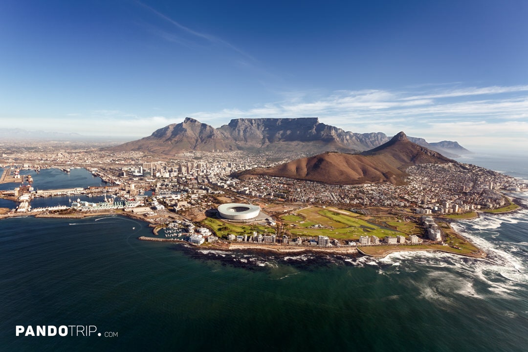
Table Mountain in South Africa is the most iconic example of a table top mountain in the world. From this African natural wonder, you can enjoy breathtaking views of Cape Town and the Atlantic Ocean. The top of Table Mountain is thought to be made up of rocks that are 450–510 million years old, far older than other famous mountain ranges like the Himalayas (50 million years) or the Alps (30–40 million years).
Standing at 1,084.6 meters (3,563 feet) high, Table Mountain’s flat summit stretches approximately 3 km (1.9 miles) from end to end.

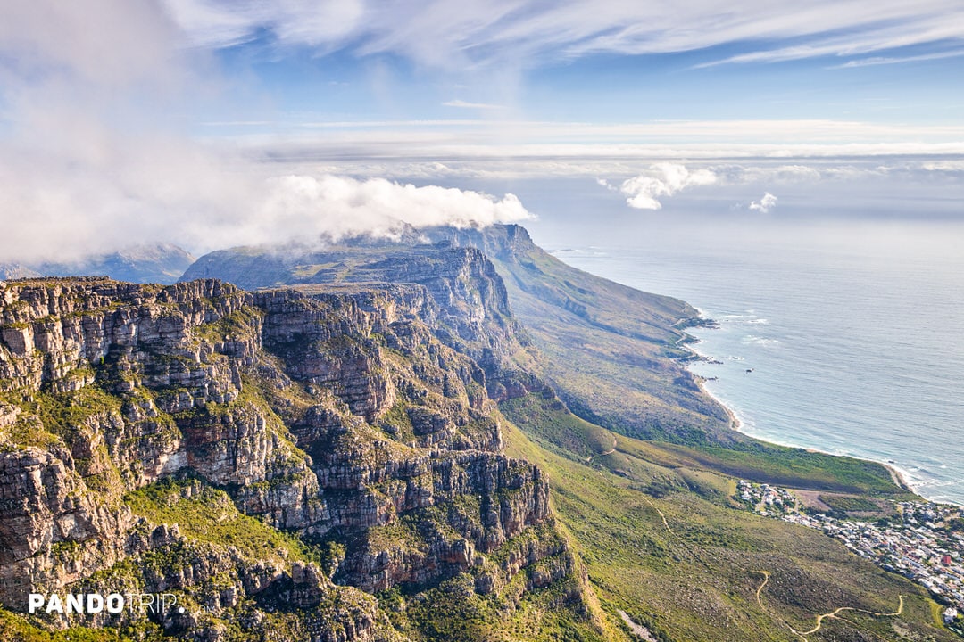
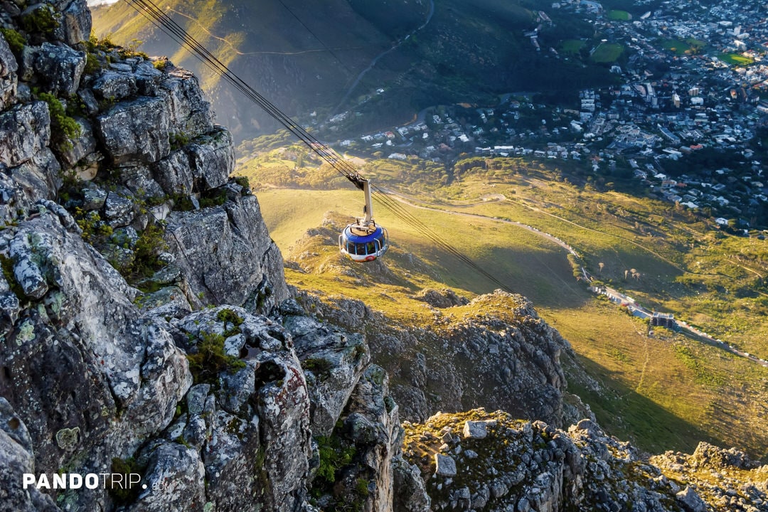
Visitors can explore the mountain through several hiking trails. The most popular routes are Platteklip Gorge and India Venster. For those not keen on hiking, the scenic Table Mountain Aerial Cableway offers an effortless ride to the top.
2. Mount Roraima, Venezuela, Brazil, and Guyana
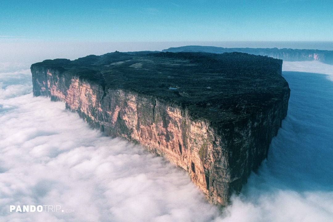
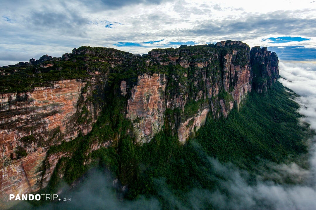
Mount Roraima is one of the most iconic table top mountains (tepuis) in South America. If the 500-million-year age of Table Mountain already sounds impressive, next to Mount Roraima, it would seem like a teenager in comparison. Located at the tri-border point of Venezuela, Brazil, and Guyana, this mountain formed roughly 1.7–2 billion years ago, making it one of the oldest rock formations on Earth.
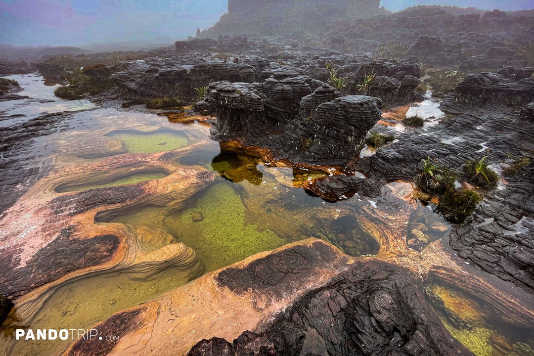
The highest point of Mount Roraima reaches 2,810 meters (9,219 feet) above sea level and lies entirely within Venezuelan territory. Its flat summit spans approximately 31 square kilometers (12 square miles) and is home to vibrant natural pools known as “Jacuzzis.” These pools are formed by rainwater collecting in the sandstone’s depressions and cracks, creating stunning splashes of color.
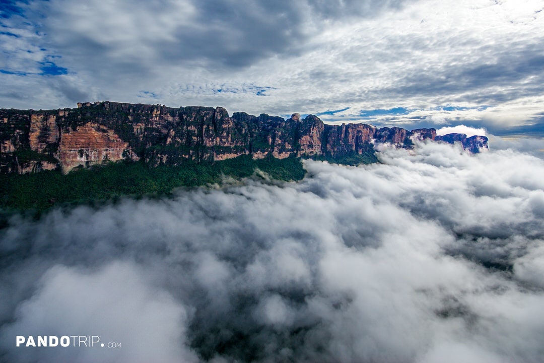
Due to its unique climate and geography, Mount Roraima is often shrouded in mist, creating a mystical, otherworldly atmosphere. Maybe that’s why it inspired Arthur Conan Doyle’s novel The Lost World, which imagines a plateau where prehistoric creatures still roam.
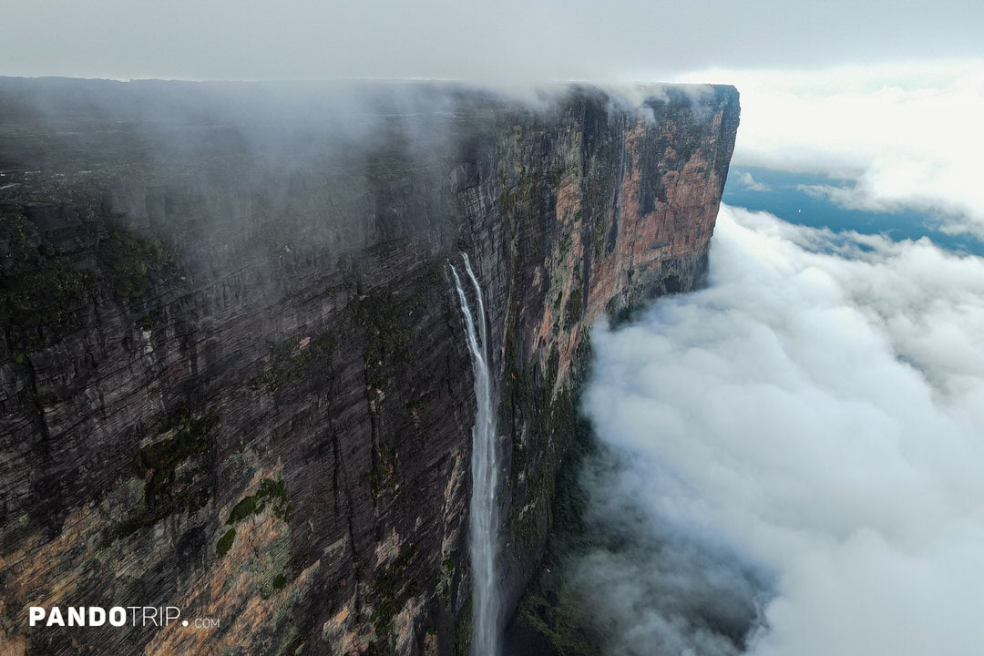
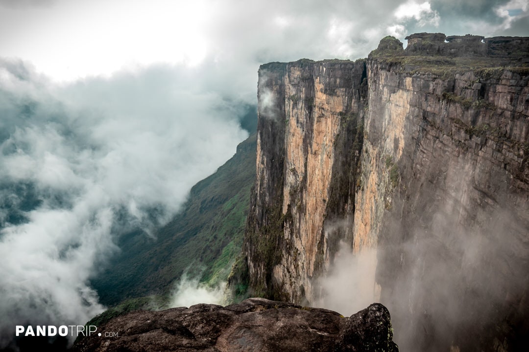
For those aiming to reach the summit, be prepared for a challenging trek. The journey typically starts in Venezuela’s Gran Sabana region, with the trek taking 6–8 days round trip. Hikers navigate through tropical forests and steep inclines before arriving at the top Mount Roraima.
3. Auyán Tepui, Venezuela
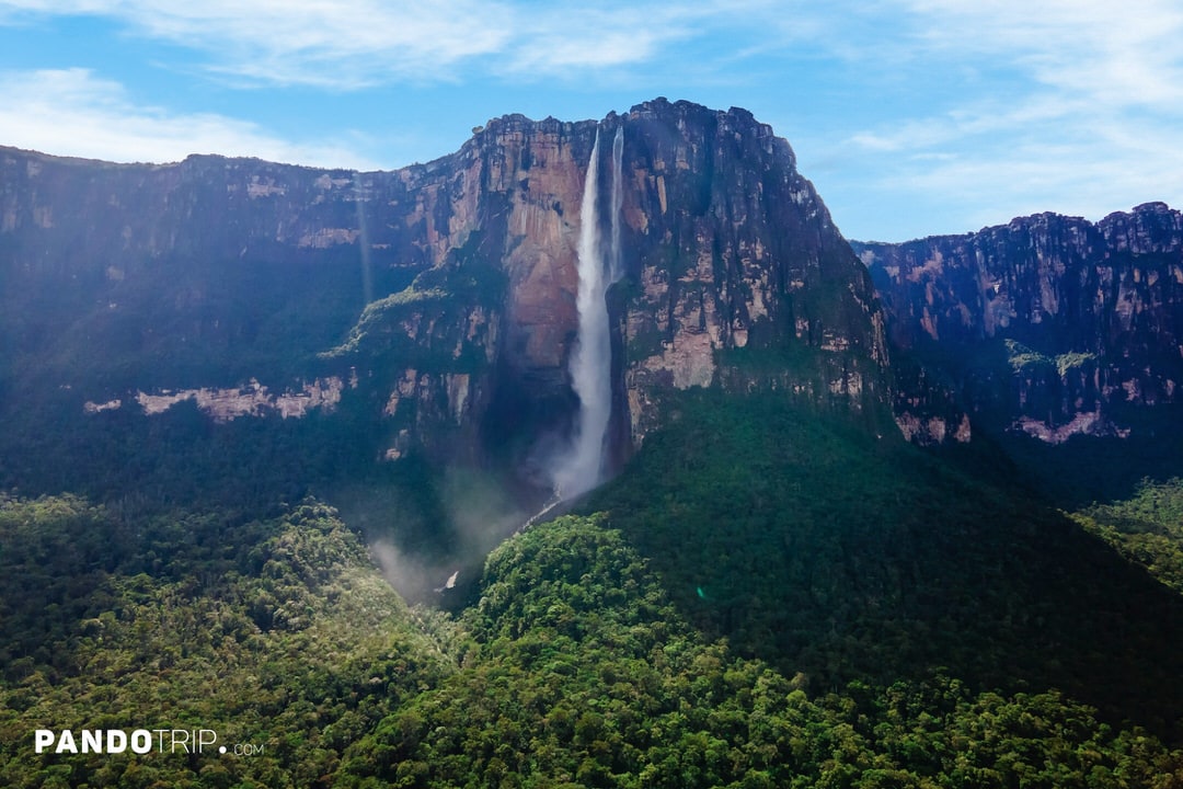
In Venezuela, you’ll also find another remarkable table top mountain – Auyan Tepui. It’s one of the most visited and largest tepuis in the Guiana Highlands. Its summit covers around 670 km² (260 sq. miles), while the mountain’s slope spans 715 km² (276 sq. miles). The uneven, heart-shaped plateau rises from about 1,600 meters (5,250 feet) in the northwest to its highest point of 2,450 meters (8,038 feet) in the southeast.
Auyan Tepui is best known as the source of Angel Falls, the world’s tallest uninterrupted waterfall, which plunges 979 meters (3,212 feet) from the mountain’s summit. Interestingly, the name Auyán Tepui means “Devil’s House” in the local Pemon language, creating a fascinating contrast with the heavenly name of Angel Falls. However, the story behind the waterfall’s name is less mystical—it was named after Jimmie Angel, an American aviator who played a key role in bringing global attention to the falls. The Venezuelan government officially recognized the name in 1939 in his honor. Locals, however, have long called the waterfall Kerepakupai Merú, which translates to “waterfall of the deepest place.”
Visitors to Auyán Tepui can explore the area through guided hikes or scenic flights. Hiking expeditions to the mountain are considered challenging, typically lasting 8–12 days, depending on the route. The journey usually begins in the Kamarata Valley, which is accessible by small aircraft from Ciudad Bolívar or Canaima.
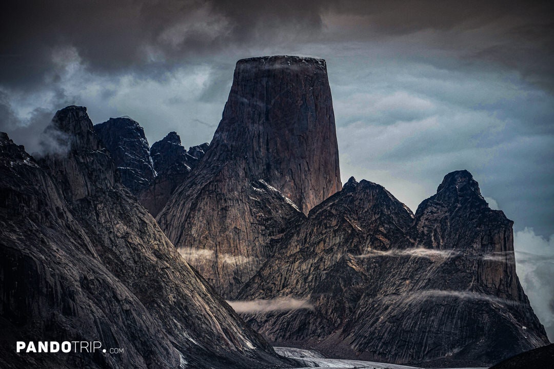
4. Mount Asgard, Canada
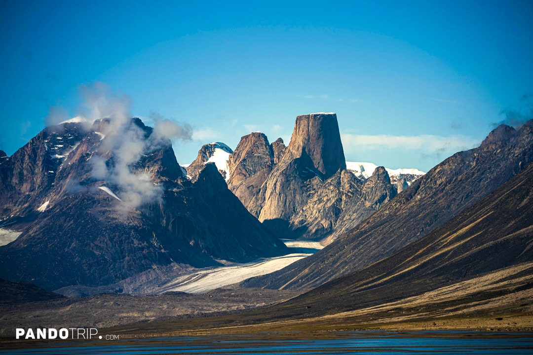
Named after the realm of the gods in Norse mythology, Mount Asgard is one of the most unique flat-topped mountains in the world. Surrounded by glaciers and the harsh Arctic tundra, it is the only twin-peaked table mountain. Mount Asgard features two flat, cylindrical granite peaks—the North Tower andSouth Tower—connected by a saddle. These nearly symmetrical peaks are an exceptionally rare geological feature in the Arctic.
Standing at an elevation of 2,015 meters (6,611 feet), Mount Asgard is part of the Arctic Cordillera mountain range and one of the most recognizable peaks in Canada’s Arctic. It even made an appearance in film history. In the 1976 James Bond movie The Spy Who Loved Me, a stuntman performed a parachute jump off Mount Asgard – considered one of the most most iconic stunts in cinematic history.
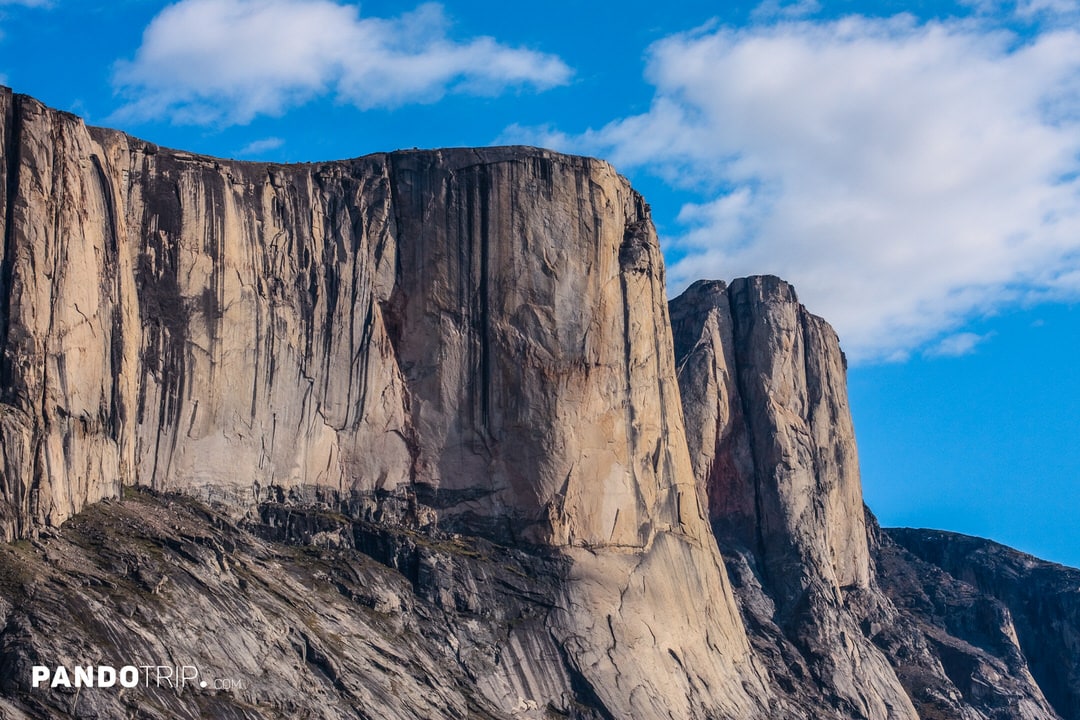
Reaching Mount Asgard is no small feat due to its remote Arctic location. First, you’ll need to fly into Pangnirtung, then cross the fjord by boat or snowmobile to the entrance of Auyuittuq National Park. From there, a trek through extreme weather conditions—fog, storms, and freezing temperatures—will bring you to the mountain’s base. Despite its challenging accessibility, Mount Asgard is considered one of the world’s best big-wall climbing destinations, thanks to its pristine granite walls and technically demanding routes.
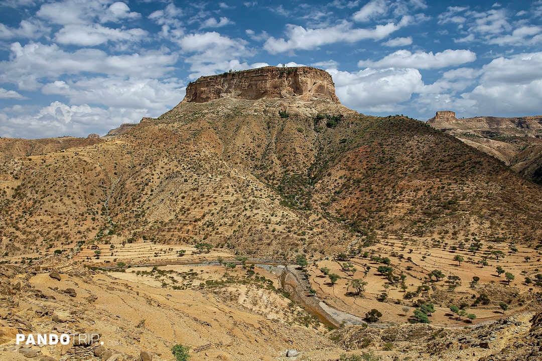
5. Debre Damo, Ethiopia
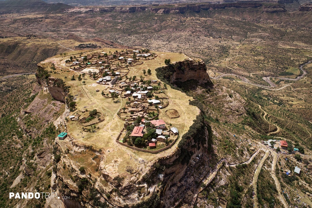
Debre Damo is part of the Ethiopian Highlands, which were formed through volcanic activity millions of years ago. Its flat top and steep sides are characteristic of an amba, a type of mesa unique to Ethiopia.
The plateau stretches about 1,000 meters (3,280 feet) from northeast to southwest and is about 400 meters (1,312 feet) wide. It’s large enough to sustain a self-sufficient community, with space for farming, livestock, and water cisterns to collect rainwater. Thanks to this self-sufficiency, steep cliffs, and isolated location, Debre Damo has been pretty much the perfect refuge and defensive spot throughout history. It even served as a sanctuary for Ethiopian royalty.
Today, Debre Damo is famous for its ancient monastery. It’s believed to be one of Ethiopia’s oldest Christian sites, dating back to the 6th century. The monastery features an ancient church built in Aksumite style, with alternating layers of limestone and wood.
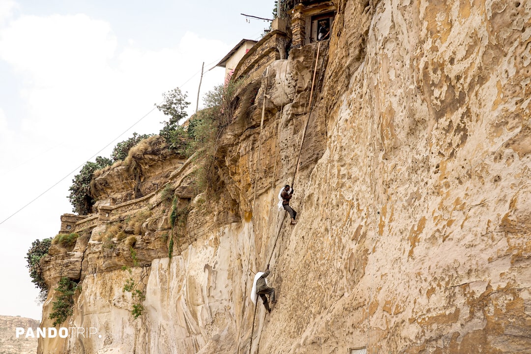
The only way to reach Debre Damo’s summit is by climbing a leather rope (called a jende) up a 15-25 meter cliff. Visitors tie the rope around their waist while monks help pull them up. Due to strict religious traditions, only men are allowed to enter the monastery.
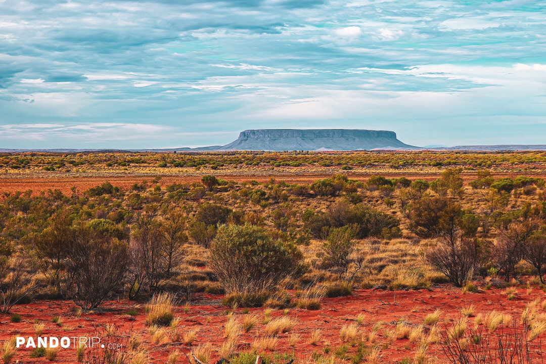
6. Mount Conner, Australia
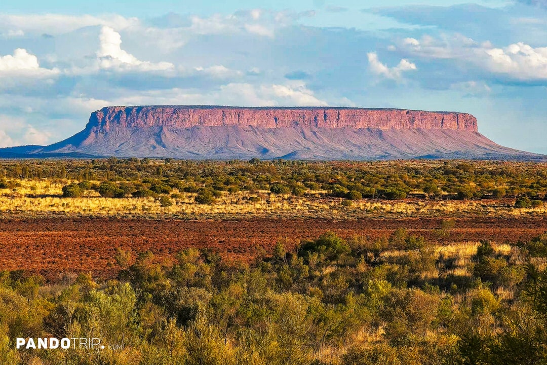
Uluru may be one of Australia’s most famous natural wonders, but just 100 km (62 miles) away lies the lesser-known yet equally impressive Mount Conner. Rising 300 meters above the surrounding desert plains, this mountain is a textbook example of a table mountain.
Interestingly, Mount Conner is often mistaken for Uluru by first-time visitors due to its visual similarity. This resemblance has earned it the local nickname “Fool-uru.” From a distance, the two may look alike, but there are key differences. Mount Conner has a flat summit, unlike Uluru’s domed shape. Additionally, Mount Conner’s base spans approximately 32 kilometers (20 miles) in circumference, making it three times larger than Uluru. Both are part of the same geological formation, but Mount Conner is significantly older.
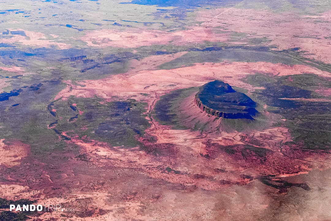
Visiting Mount Conner independently isn’t possible, as it’s located on private land. However, guided tours are available, offering the chance to get up close to the mountain, explore the surrounding salt lakes, and spot native wildlife like emus and kangaroos.
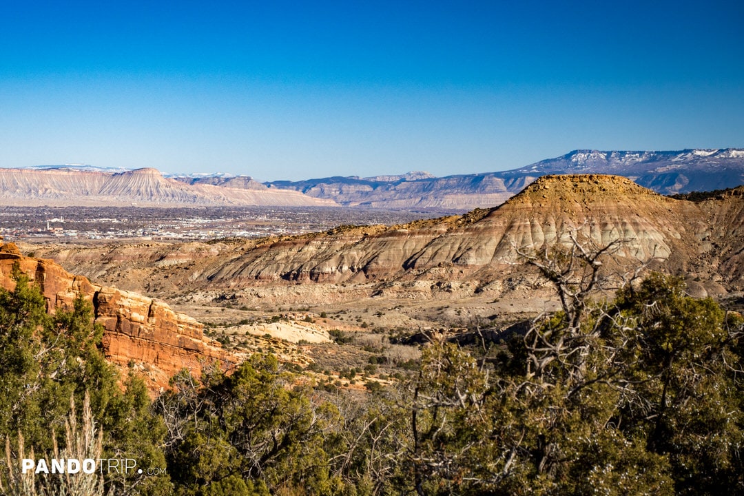
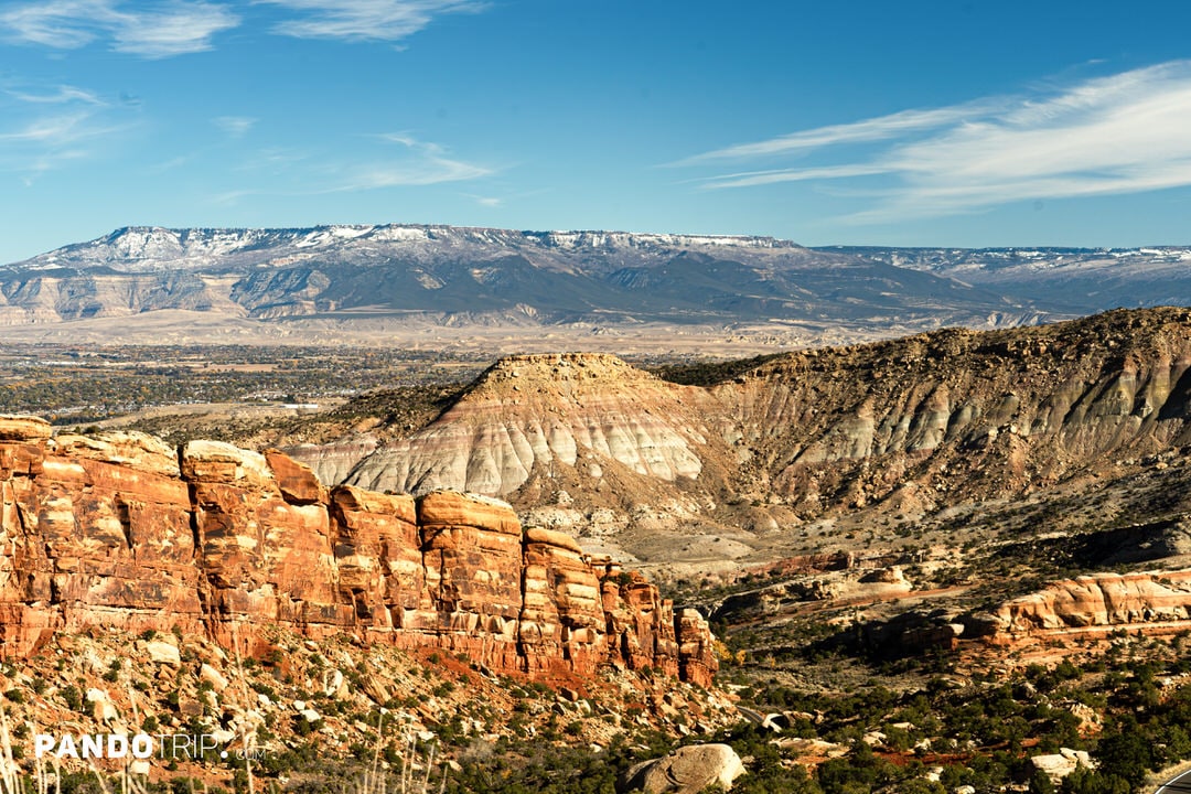
7. Grand Mesa in Colorado, USA

Located in Colorado, USA, Grand Mesa is the largest table mountain in the world. It spans over 1,300 square kilometers (500 square miles)and rises more than11,000 feet (3,350 meters)above sea level Its flat summit is covered with a layer of basalt formed millions of years ago due to volcanic activity. This layer made the mesa resistant to erosion, while rivers carved out the lower layers, giving Grand Mesa its unique shape.
Grand Mesa offers activities for visitors year-round. In summer, it’s perfect for hiking, with over 50 trails, including the stunning Crag Crest Trailand theLands End Observatory. Anglers will love the more than 300 lakes, around 200 of which are great for trout fishing. For those wanting to stay longer, there are plenty of camping areas.
In winter, Grand Mesa transforms into a snowy wonderland, receiving over 640 cm (250 inches) of snow annually. This makes it ideal for cross-country skiing, snowshoeing, and snowmobiling. For downhill skiing, visitors can head to Powderhorn Mountain Resort. And for fishing enthusiasts, the same lakes that are popular in summer become prime spots for ice fishing.
8. Amedi, Iraq
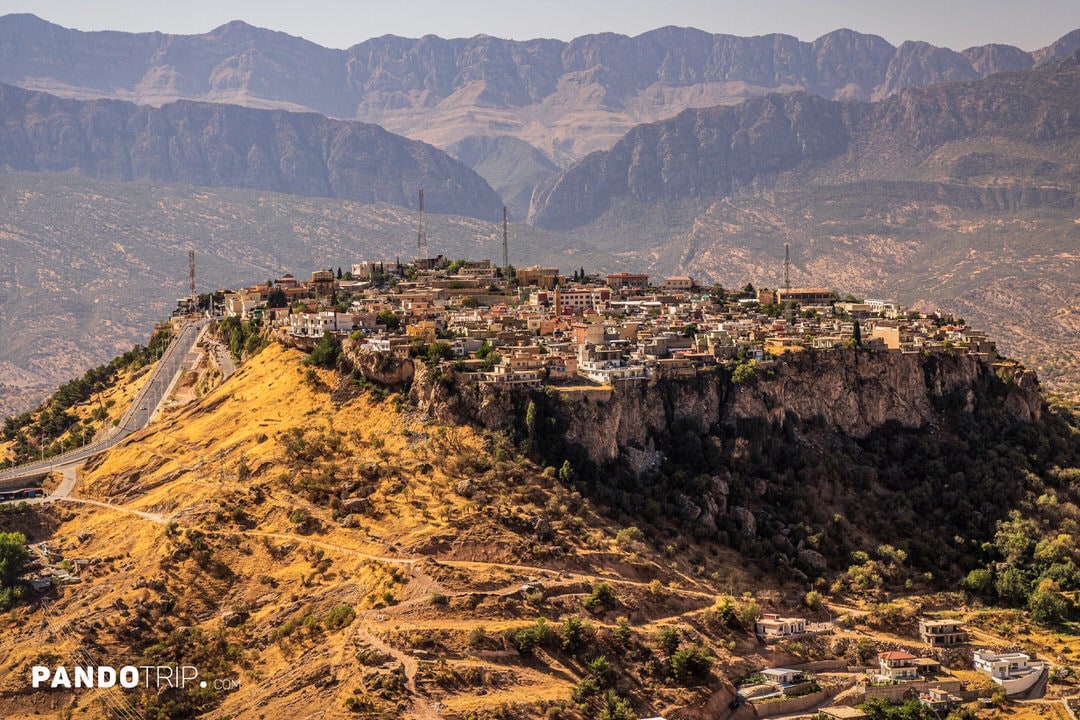
In Iraq, you can find an entire town built atop atable mountain. Located near the Iraqi-Turkish border, Amedi (also known as Amadiya) sits at an elevation of approximately 1,200 meters (3,937 feet) on a flat-topped hill surrounded by steep cliffs. The town is accessible via a single winding road, and its natural fortification has made it a strategically significant location throughout history. Over the centuries, Amedi has been both a strategic and cultural center, with its elevated position offering a strong defensive advantage.
Amedi attracts visitors with its stunning natural beauty and rich cultural experiences. The town offers breathtaking views of surrounding mountain ranges and valleys. Nearby, you’ll find Sillav Waterfall and lush fruit orchards where visitors can enjoy local produce such as grapes and figs.
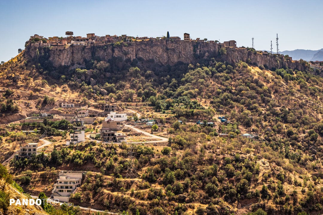
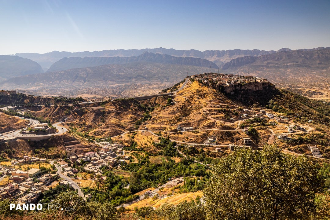
The town is also home to numerous cultural and historical landmarks, including a 16th-century minaret built during the rule of Sultan Hussein Wali, and two ancient city gates—the Zibar Gate and Mosul Gate—marking historic entrances to Amedi. Visitors can explore the bazaars to purchase local goods, with Amedi being particularly famous for its high-quality tahini (sesame paste) and honey.
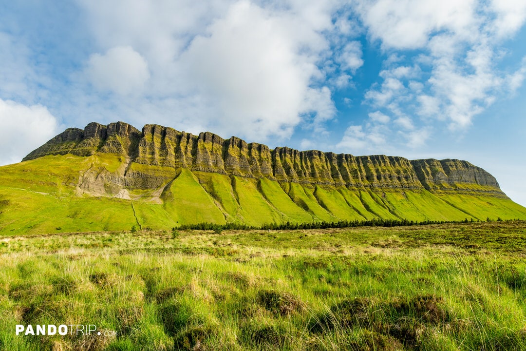
9. Benbulbin, Ireland
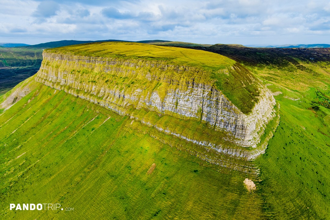
Often dubbed Ireland’s “Table Mountain,” Benbulbin (also spelled Benbulben) dominates the skyline of County Sligo. Rising 526 meters (1,726 feet) above sea level, this flat-topped giant crowns the Dartry Mountain range and can be seen for kilometres along the Wild Atlantic Way. Its dramatic north face—sheer limestone cliffs capped by a perfectly level summit—contrasts sharply with a gentle, grassy slope to the south, giving Benbulbin its unmistakable profile.
Benbulbin began life as part of a vast Carboniferous limestone plateau laid down some 340 million years ago in a warm, shallow sea. During the last ice age, glaciers scoured the plateau from north-east to south-west, carving out the cliffs and leaving behind the tabletop silhouette we see today. The upper layers are hard Dartry Limestone, while the lower, smoother flanks consist of shale; fossilised corals and sea shells are common in both layers, echoing the mountain’s marine origins.
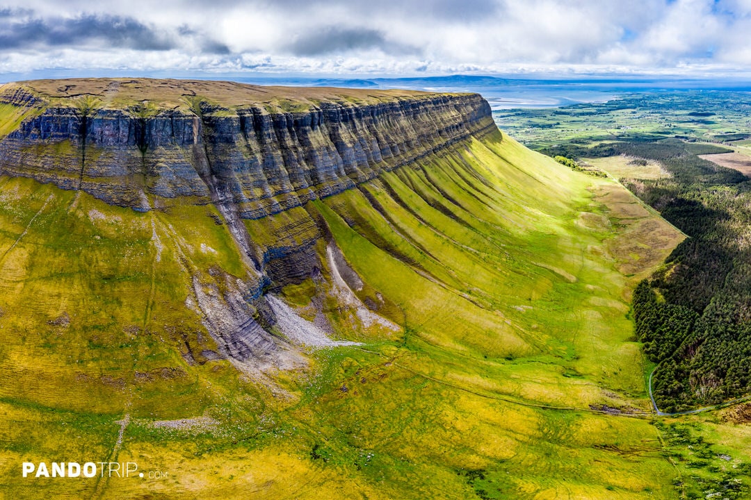
For walkers, the safest and most popular approach is the Gortarowey (Benbulbin Forest) loop on the southern side—an easy 5.5 km circuit that winds through conifer forest before emerging onto open moorland with sweeping views of Donegal Bay. Fit hikers can continue to the summit in about two hours, but should avoid the exposed northern cliffs, where fierce Atlantic winds and loose scree make conditions treacherous. On a clear day, the tabletop rewards climbers with panoramic vistas of Sligo town, Yeats’s Drumcliffe graveyard and the blue sweep of the Atlantic.
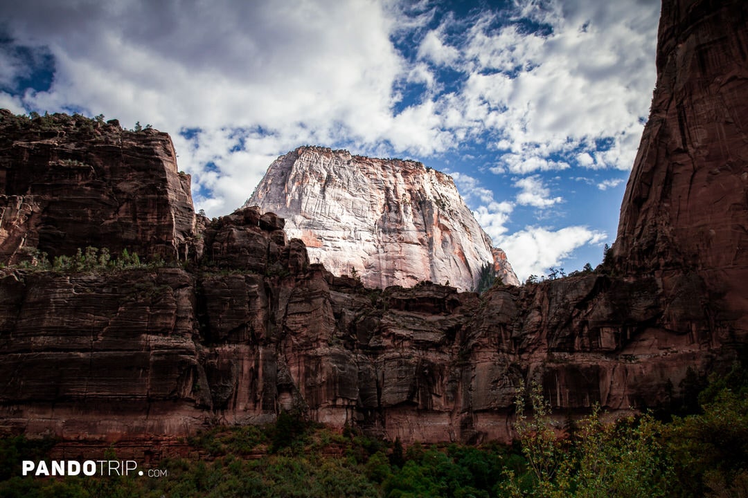
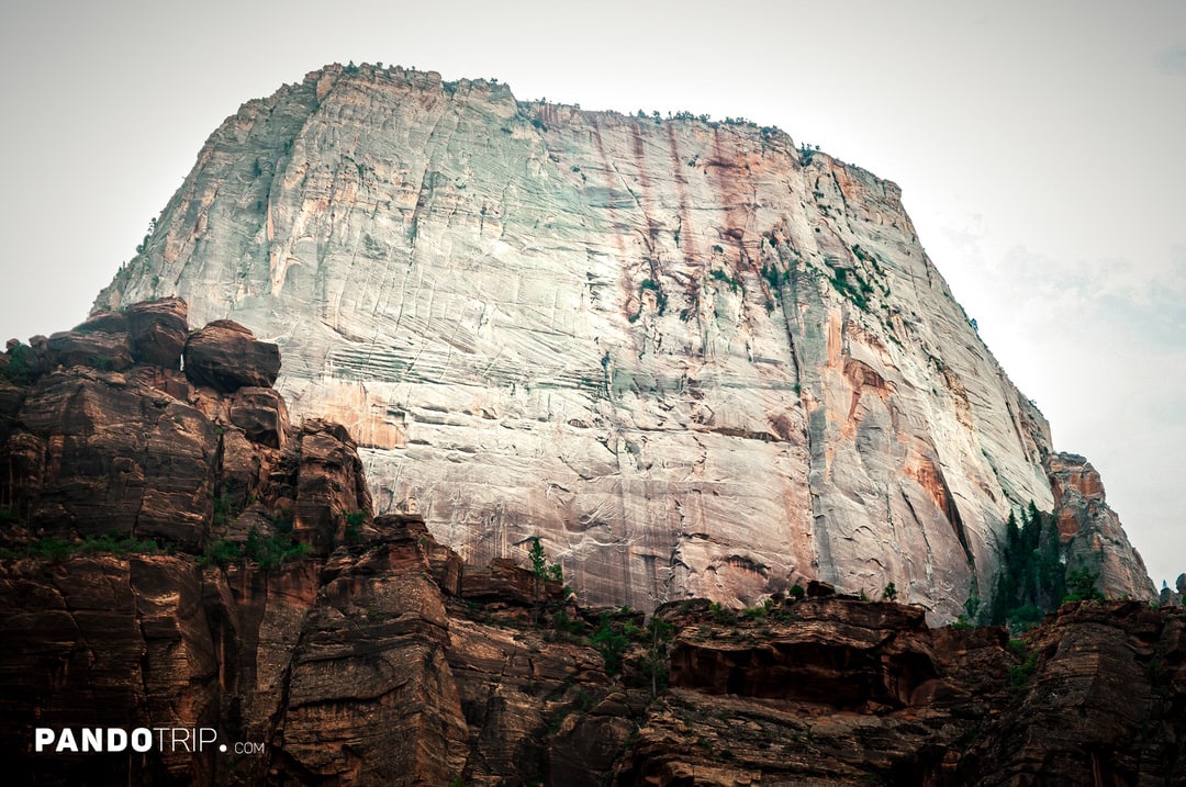
10. The Great White Throne, Zion, USA
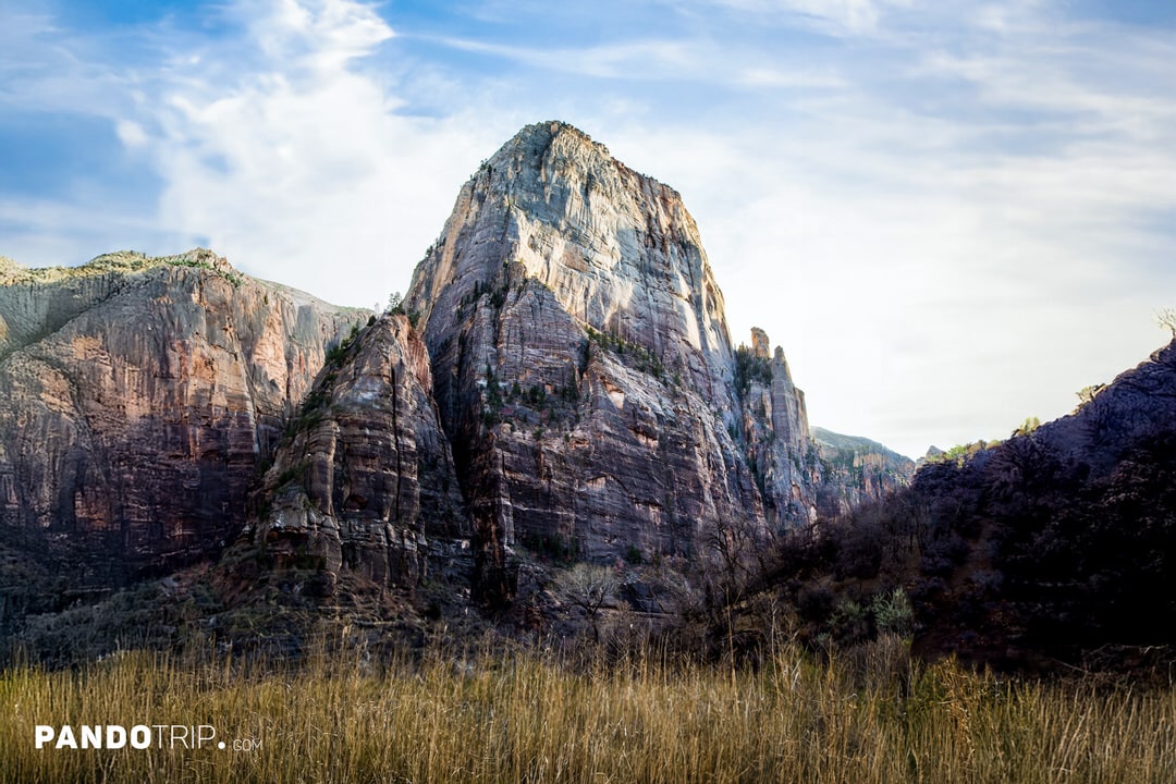
The Great White Throne is a stunning mesa made of white Navajo sandstone. With its flat top and steep cliffs, it’s a classic example of a table top mountain shaped by erosion. It’s also one of the most iconic landmarks in Zion National Park. Towering 730 meters (2,400 feet) high, its white color stands out sharply against the surrounding red and orange sandstone formations.
This massive monolith is located near the famous Angels Landing. Hikers on the Angels Landing and Emerald Pools trails get incredible views of it along the way. For those who prefer not to hike, the park’s shuttle buses along the Zion Canyon Scenic Drive offer excellent views from several scenic stops where the throne is prominently visible.
The Great White Throne is also popular among rock climbers. No permits are needed for day climbs, but overnight climbs anywhere in Zion National Park require a permit. Additionally, climbing on the Great White Throne is prohibited annually from early March to mid-July to protect nesting peregrine falcons.